Soil Erosion About
Wednesday, May 18, 2022 3:20 AMDescription
Soil erosion is a natural process defined as the gradual movement and transport of the upper layer of the topsoil by different agents, especially water and wind. Under natural conditions, soil erosion is compensated by soil formation, so that to maintain a dynamic equilibrium. However, human activities can exacerbate soil erosion leading to soil degradation and excessive soil loss. The most drastic form of soil erosion is gullying.
Why monitor soil erosion for interventions on freshwater ecosystems?
Deposition of eroded soil particles from hillslopes occurs often in locations where excess soil particles are undesirable such as streams, lakes, reservoirs, or deltas. Off-site (away from hillslopes) problems arise from decreased water quality, diminished aquatic biodiversity, sedimentation of downstream systems and reduced water holding capacity of reservoirs.
Does terrestrial ecosystems impact soil erosion?
Forest cover is a widely accepted measure to control soil erosion around the world. Therefore, any activities leading to deforestation can increase soil erosion. One factor attributed to this is the reduction on the kinetic energy of the raindrops provided by a dense forest canopy. Tropical and sub-tropical regions are particularly vulnerable to soil erosion once without their protective cover from the dense forest because the intensity of rainfall can be more important to the high risk of erosion in comparison to the fragility of the tropical soils to erosion. This is because tropical raindrops are typically short and intense with high median drop size, hence with high total energy load. Once the upper soil layers have been removed; the underlying, highly weathered, often very fine substrate is exposed. This offers limited resistance, and the ground rapidly becomes deeply dissected by rills and gullies.
How is soil erosion monitored?
There are several methods to monitor soil erosion with varying degrees of complexity. These include:
- Bottle tops: Several bottle tops are pushed into the surface of the soil in areas vulnerable to erosion. The bottle top protects the soil underneath so that when the surrounding soil erodes, the soil underneath the top will remain and form a pillar. Pillar is measured over time.
- Watch water flows: The locations where water converges and flows in small channels on land are determined as these areas are most vulnerable to erosion. Once these areas are known, one inspects them regularly. It is then possible to determine any erosion as soon as it appears and/or the potential to continuous erosion decreases or increases.
- Erosion pins: A metal pin such as the tent peg is banged into the ground, marking where the ground surface is (and using a marking pen or paint that will not come off in the wet). If the soil is eroding, a gap will develop between the mark on the pin and the soil surface.
- Ground cover: Visual indicator of ground cover is used. A minimum of 70% cover is recommended to protect soil from erosion, but, on some areas, 90-100% cover is recommended.
- Indicators of soil health: Simple equipment can be used to assess a combination of soil characteristics (biodiversity, root development, soil structure, slaking or aggregate stability, and soil pH) that contribute to detecting deterioration (or improvement) in soil’s condition over time.
Over what time scale would you typically expect to see improvement in soil condition?
The pathway of change for soil erosion is highly variable. It depends on the type of erosion, soil type, erosion control measure, land use, edaphoclimatic characteristics, agronomic practices, and terrain slope. Therefore, estimating how long it may take to see reductions in soil erosion is not advisable. What we highlight in the pathway of change, instead, are the key variables for which changes can signal a positive or negative trend towards controlling erosion.
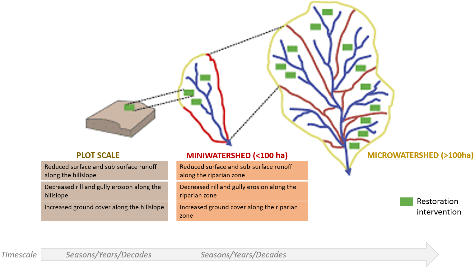 Figure 1 Pathway of change for soil erosion