Soil Erosion Groundcover
Wednesday, May 18, 2022 4:47 AMMethod description: Groundcover
Groundcover is the percentage amount of plant material (dead or alive) that covers the soil surface. 100% groundcover means that the soil cannot be seen, and 0% groundcover is bare soil. In most landscapes there is usually some form of groundcover on the soil surface. Farming systems have groundcover in the form of annual or perennial pastures or crops.
The method suggested here is a visual assessment of groundcover. A minimum of 70% cover is recommended to protect soil from erosion, but, on some areas, 90-100% cover is recommended.
The details provided below are adapted from Agriculture Victoria explaining a very straight forward method useful for a quick and cheap assessment.
Sampling design
The sampling design depends on what one is trying to achieve, for example: restore a particular area or assess groundcover of an entire farm, or area of interest, to assess the risk of erosion. The areas to be monitored must be recorded and their location determined with a GPS.
When monitoring it is important to make sure that the areas being assessed are representative of the entire area. The larger the area, the more assessments one needs to take. Do a quick walk over the general area to understand how variable the groundcover is. If an area seems uniform, then 8 to 10 assessments may provide a good indication of the average groundcover. In areas of high variability, do at least 15 or more assessments.
Use a zigzag (random) transect For example, take 10 steps in one direction randomly turn and take another 10 steps in the other direction. Make sure to draw the transect roughly on a piece of paper and note approximately where the assessments were taken and use a GPS to reference each sampling site.
Groundcover is seasonably variable. Find out the time of year when groundcover is at its lowest level, this is when the risk of soil loss through erosion is highest, thus, when the groundcover monitoring should be focused. In some cases, it may be advantageous to monitor twice a year. Always, record the dates in which the assessments have occurred.
Make a 30cm by 30cm quadrat (square) out of sturdy cardboard, wood or wire. A quadrat is used to help focus the eye on a defined area for assessment. Along the predetermined transect line, throw the quadrats out at random and visually assess the groundcover in the quadrant, comparing it with the following photo standards. Record the assessments using this Tool A pro forma for recording groundcover.
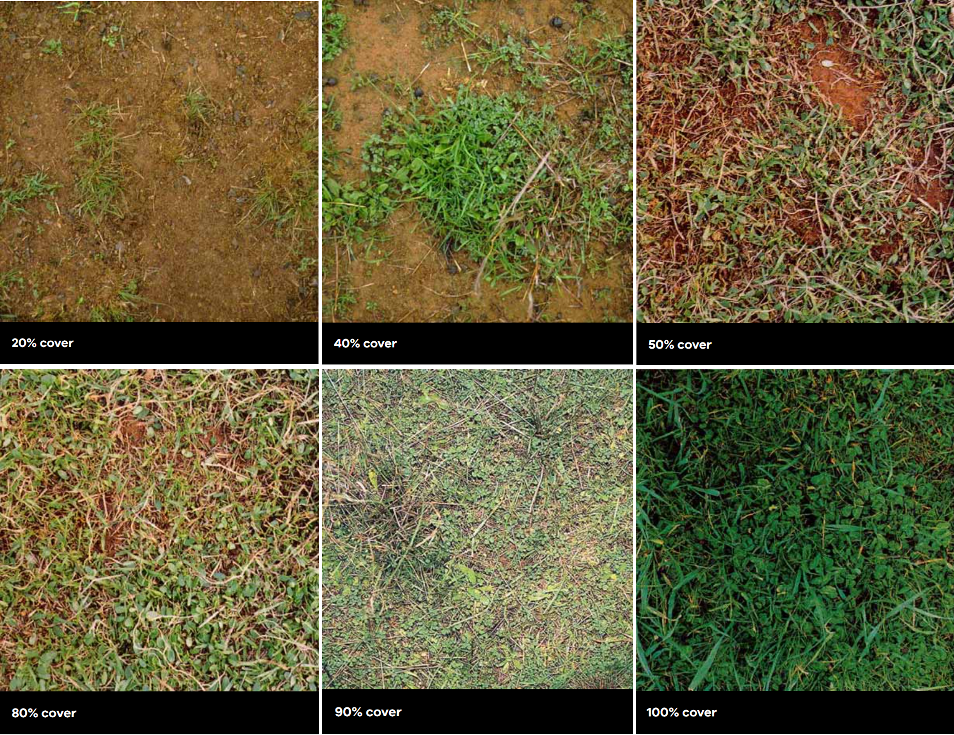
Figure 1 Visual groundcover scale
Quantification method to assess groundcover
Averaging the measurements in each area monitored provides an overall percentage groundcover for a particular area. These can then be compared to other areas of the farm and priority can be made to the areas of low groundcover percentage regarding on-ground works.
To calculate the average groundcover: add up all the percentages taken in the same area and divide that by the number of assessments taken in that area. For example:
- Add 5 samples taken in paddock 10B: 70%+ 90%+ 40% + 70% + 40% = 310%
- Divide the total by the number of samples taken: 310/5 = 62%
Use Pro forma Tool B calculating average groundcover assessments.
Main costs
The costs include the cost to make field quadrants, GPS, and field trip costs.
Preparation for a field day
The basic for steps to prepare for a field day to characterize groundcover.
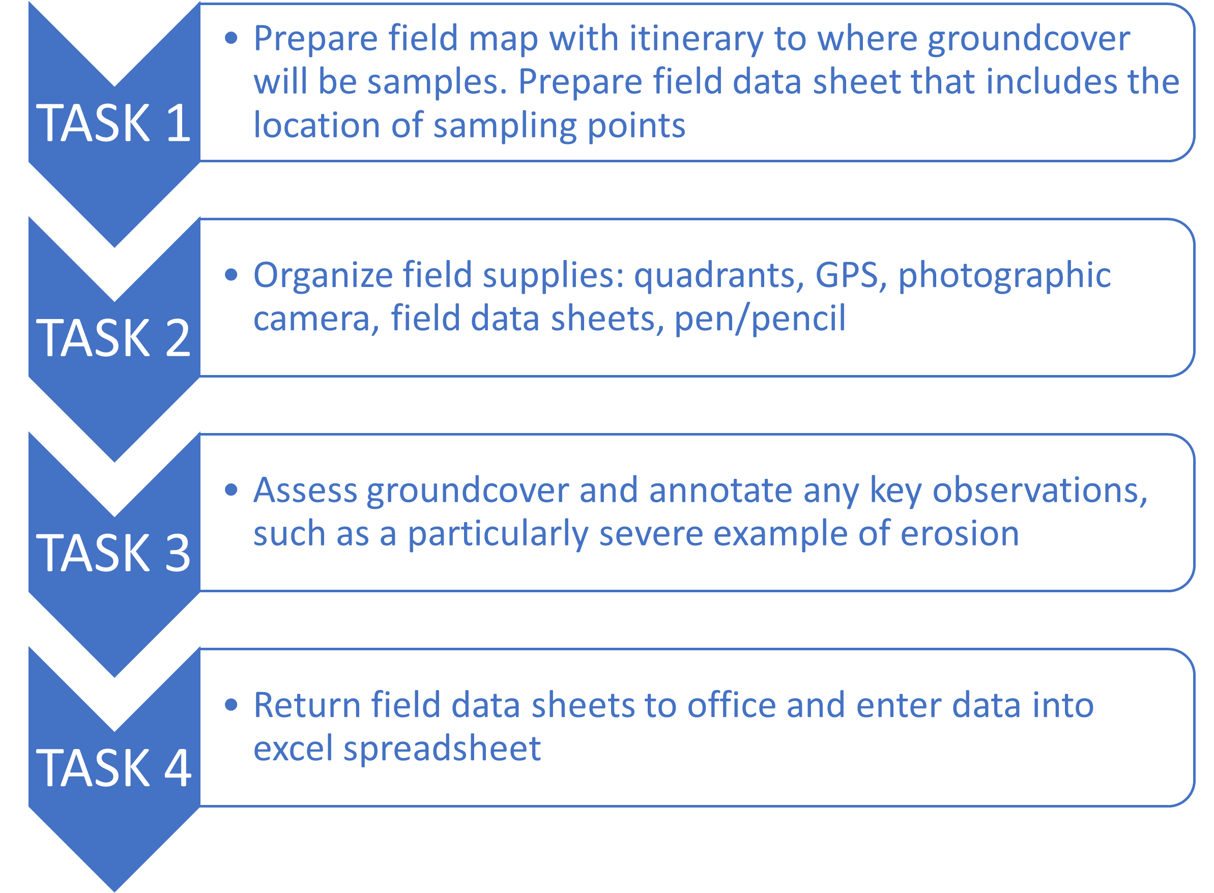
Figure 2 Basic tasks for a successful field day to characterize groundcover