Water Quality Streambed-stability
Wednesday, May 18, 2022 5:19 PMMethod description: Stream bank erosion
The rapid, visual-based stream stability assessment (SSA), developed by Aloterra, LLC is an interesting option to estimate both streambed stability. Details on the SSA method can be found here. Briefly, using visual assessment, field crew selects the dominant bed sediment type and dominant morphology type for each stream reach. Presence of active or recent incision is noted. Clues from positions of roots along the bank and presence of migrating headcuts help inform this. Finally, if recent or active incision exists, the field crew estimates the depth of erosion along the sub-reach. Active incision may occur at or as a result of a stream restoration structure failure.
Sampling design
The monitoring objectives and the intervention type and configuration will determine the approximate location of the stream or river station.
Site-specific characteristics must also be considered to ensure a successful project. Physical constraints of a site, the time required to reach the location, legal and physical access to a site and safety issues must be considered when making site selections.
The monitoring of streambed stability is conducted at the stream segment according to the figure below.
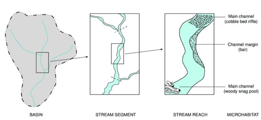
Figure 1 Spatial hierarchy of basin, stream segment, stream reach, and microhabitat (from Fitzpatrick et al. 1998)
The assessment visual and is conducted along a 30-60-m stream segment within which bed information is aggregated. The length of the sub-reach may vary according to the channel size, but its length should be on the order of 10 to 20 times the bankfull width of the channel (floodplain edge to floodplain edge).
Surveys are conducted once per year to allow inter-annual comparisons. Yearly surveys provide data for longitudinal assessments of channel evolution.
Quantification methods to assess streambed stability
The general assessment procedure involves characterizing the dominant bed sediment type and dominant morphology type as well as characterizing presence and severity of any incision.
For each reach, assign percent of each material category. Note that cohesive banks are composed of soil, which has a certain percentage of silt and clay. Non-cohesive banks lack silt and clay, though can be a mixture of sands, gravel, cobbles, etc. The figure below contains descriptions and lengths associated with each sediment class.
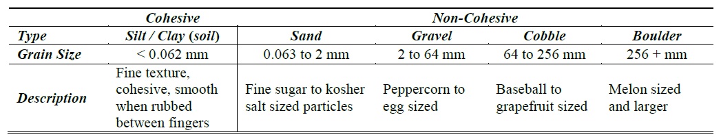
Figure 2 Grain size description
The goal is to complete the following table with a description of each assessment category. The table also provides an example of how to complete it.
Table 1. Bed stability field assessment with example (in italic and gray highlight)
| Bed composition (%) | Cohesive ( ) | Sand (5 ) | Gravel (45 ) | Cobble/Bolder ( 50 ) | Bedrock ( ) |
|---|---|---|---|---|---|
| Bed morphology | Cascade | Step-pool | Riffle/Glide | Pool/Riffle | Dunne/Rip |
| Recent/active incision? | YES | NO | Aggradation? | YES | NO |
| Severity incision | < 30cm | 30-60 cm | 60-90 cm | >90 cm | |
| REACH NOTES:* |
*Example: Recently dead trees counted as living as roots are still providing stability. River right riparian veg includes top of a levee. Riff/glide transitions into pool at d/s end, then another riffle d/s of this reach.
A handheld GPS may be used to mark the starting point of each sub-reach as well as the location of any failed stream restoration structures. Stream stability information may be later incorporated into a GIS database allowing the stability metrics to be mapped. Photos should be taken of any noteworthy observations, such as a particularly severe example of erosion or a failure restoration structure. Notes should be taken of the photo numbers, any waypoints collected on the GPS, as well as one to two sentences of narrative describing the cross-section.
To calculate bed stability scores, data collected on each reach is entered into the ‘Calculations_Spreadsheet’ according to the figure below. Each column represents one stream reach. Calculations are based on weighted means provides as indicated in the figure. Higher scores indicating a higher risk of instability.
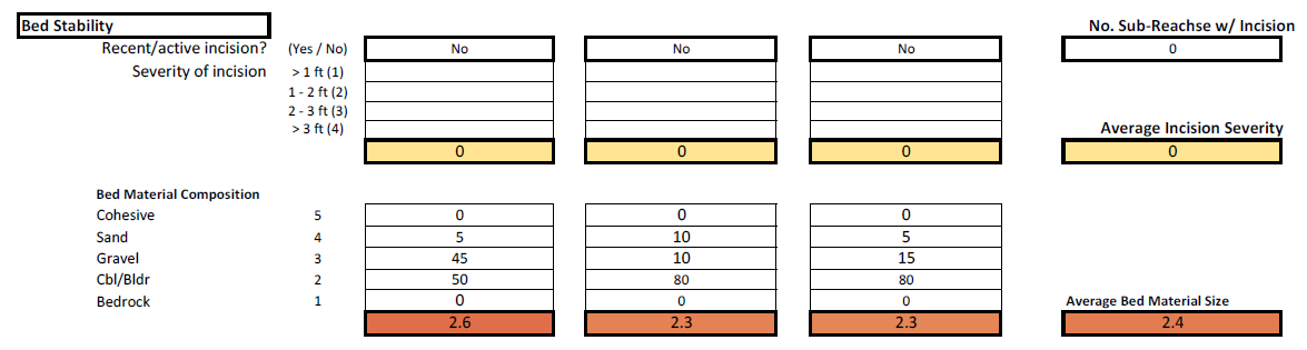
Figure 3 Bed stability calculation sheet with example
Find here the description of each assessment category and the field sheet.
Main costs
The main costs are associated with field trips and GPS as the assessments only require data field sheets, pen/pencil and a measuring tape. GPS in this webpage are good options; webpage also provides costs.
Preparation for a field day
The basic for steps to prepare for a field day is detailed in the figure below.
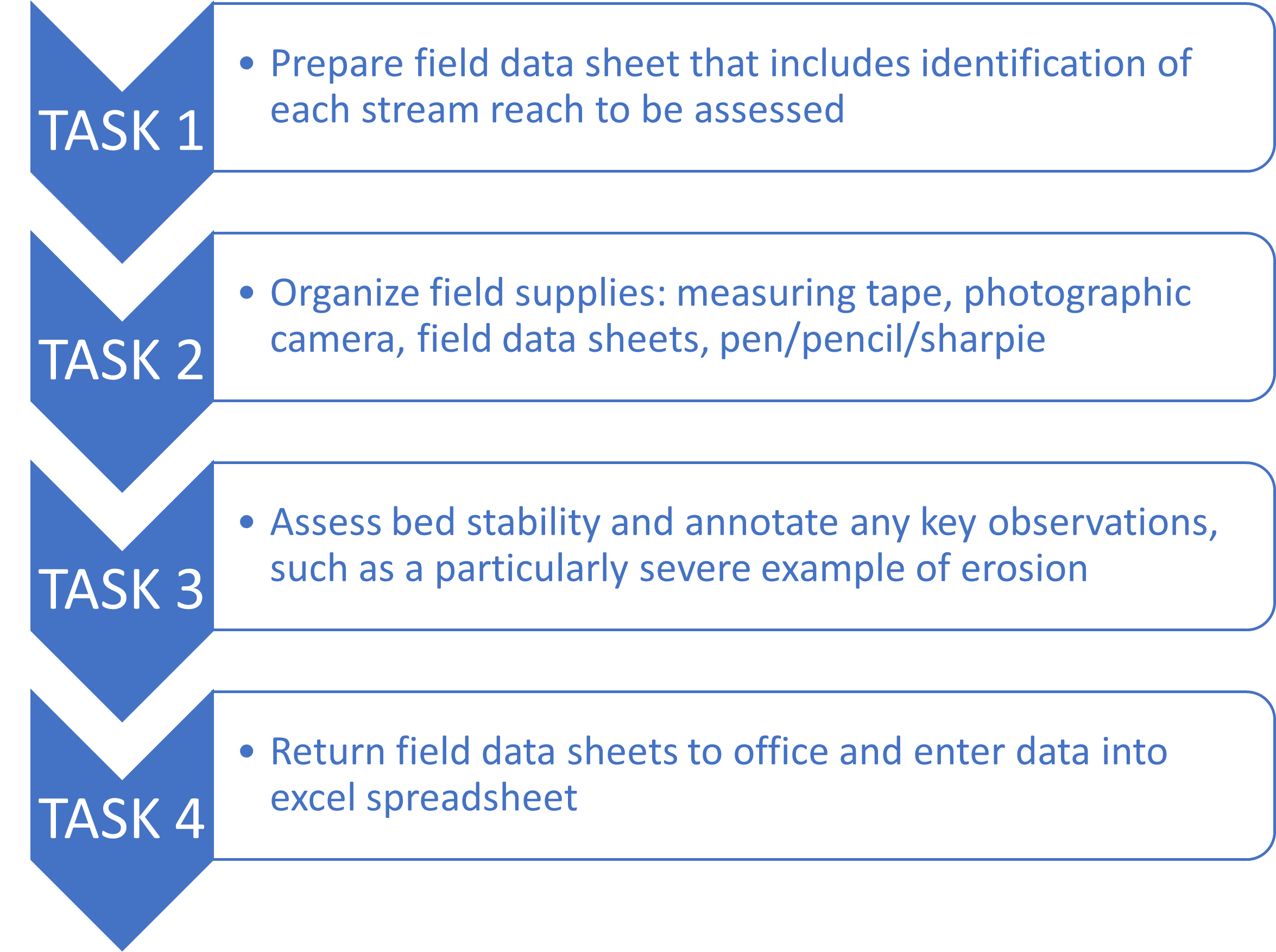
Figure 4 Basic tasks for a successful field day to characterize water quality